Dinas Island
Pembrokeshire
465 foot SEA cliffs
Dinas Head
Situated to the east of Fishguard Harbour and west of Newport , Dinas Island juts out into the sea and is often referred to as the dolphins nose.
From the northern tip of Dinas Head where the cliffs climb to 465-feet high above sea level and the highest point of the island, you can enjoy views of Cardigan Bay and the Lleyn Peninsula of Anglesey and on a clear day the top of Snowdon and even the Wicklow Mountains can be seen.
Dinas Island is separated from the mainland by marshland with a stream running through a deep valley between the two small beaches of Cwm-yr-Eglwys (Church in the Valley) and Pwll Gwaelod (Bottom Pool). The three mile circular walk from one beach to the other around the cliffs (or 1 mile accross the valley) is one of Pembrokeshires most popular stretchs of the National Park Coastal Footpath, with its steep climb and descent providing plenty breath taking sea and mountain views.
The Island itself was owned during World War II by the author and naturalist Ronald Lockley, also known for his brief residence on Skokholm Island and his writings about his island life.
After the war the farm was bought from Lockley by Norman Perkins, a local farmer from St Davids, and is today still farmed by the Perkins family although now owned by the Natural Trust. The farm has received many farming accolades whilst under the Perkins management including, Farmers Weekly Sheep Farmer of the Year and British Grassland Management Farm of the Year.
The farmhouse itself dates back to the 1600’s and has many myths and stories surrounding it with smugglers caves and tunnels leading from the sea to the house.
Cwm-yr-Eglwys is home to the little 12th century seaside church of St Brynach, it became a victim of the sea during horrendous storms which severly damaged this stretch of coastline coast in 1859, also causing the wreck of the Royal Charter off the North Wales coast.
It was not the first time the church had been destroyed, for the Vikings knocked it down almost a millennium earlier. In 1979 another violent storm did further damage and only the belfry, west wall and part of the churchyard now survive. Now visitors sunbathe and picnic on the green grass of the churchyard, only a few feet above the beach, which has earned a Seaside Award and a Green Coast Award, similar to the Blue Flag beach accolade. A narrow slipway is used for launching small boats, for which the bay is a safe sheltered harbour in summer weather.
The local boat club organises sailing events and regattas during the first two weeks of August every year. Sheltered from the prevailing winds, Cwm-yr-Eglwys enjoys its own microclimate, experiencing temperatures a few degrees warmer than other parts of the Pembrokeshire coast, and a fair bit drier, which allows the growth of trees and shrubs of near Mediterranean luxuriance. Of interest to visitors on the seafront is a scale model made by the local blacksmith of a trading vessel of the type that would have sailed these waters at the time of the 1859 storm.
To the east are four bays where budding geologists will find at low tide some of the best examples of wave-cut platforms in the County, while in the valley near Pwll Gwaelod is evidence of an east-west Glacial meltwater channel, the old lime kiln and of course the Old Sailors pub and resturant.
Visit PEMBROKESHIRE
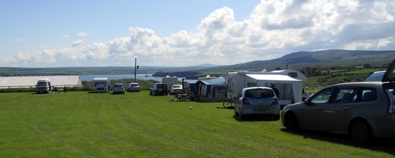
The Campsite
Situated on Dinas Head , the campsite is accessed from Pwllgwaelod beach and is within a 10 minute walk of both Pwllgwaelod and Cwm-yr-Eglwys beaches and the famous Pembrokeshire Coast Path

